
Mexico City Prepares for 2026 World Cup: Traffic Restrictions and Mobility Plan
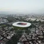
As the 2026 World Cup countdown begins in Mexico City, authorities are finalizing a comprehensive mobility plan to manage the influx of fans and ensure smooth operations around the Estadio Ciudad de México (Estadio Azteca). This plan includes security perimeters, vehicular restrictions, and alternative routes, primarily impacting the Coyoacán borough and parts of Tlalpan.
What are the Affected Areas and Roads?
The mobility measures will mainly affect the following neighborhoods and avenues:
- Affected Neighborhoods: Santa Úrsula Coapa, Pedregal de Santa Úrsula, Bosques de Tetlameya, Cantil del Pedregal, Coapa, and areas near Taxqueña.
- Affected Roads:
- Circuito Estadio Ciudad de México
- Avenida Santa Úrsula
- Calzada de Tlalpan
- Avenida del Imán
- Calzada Acoxpa
- Viaducto Tlalpan
- Various secondary streets immediately surrounding the stadium
The objective is to ensure the safety of attendees and facilitate their entry and exit from the stadium. Special mechanisms might be established for residents and essential services within the security perimeter, with specific details to be announced closer to the match dates. Parking on public roads around the venue will also be restricted.
FIFA’s ‘Last Mile’ Operation and Public Transport
A key part of the strategy is FIFA’s ‘Last Mile’ operation, which prioritizes pedestrian mobility and public transport around the stadium. This means:
- Pedestrian Access: Dedicated pedestrian access routes will be established.
- Public Transport: Public transport services such as Metrobús, Trolebús, RTP, and other mass transit systems will be reinforced. Additionally, remote parking schemes will be implemented to reduce vehicle load in the area.
Authorities emphasize that public transport will be the best alternative for those attending the matches.
Alternative Routes and Schedules to Avoid Traffic
Traffic operations will be concentrated primarily during the hours leading up to and immediately following the matches. While definitive schedules will depend on each game, restrictions are expected to begin several hours before kick-off and remain active until the stadium is cleared.
Drivers are advised to use alternative routes away from the immediate vicinity of the stadium. Key alternatives include:
- Avenida Insurgentes Sur
- Avenida Universidad
- Eje 10 Sur
- Central lanes of Anillo Periférico
- Eje 6 Sur
- Eje 8 Sur
- Calzada de la Viga
It is crucial for both residents and motorists to plan their commutes in advance to avoid delays during one of the planet’s most significant sporting events.
Where to Find More Information?
Stay tuned for official announcements from Mexico City’s mobility and security agencies for the most up-to-date information on closures, restrictions, and public transport schedules.